
Type Data Output from Weather Radar : PPI
Labels:
data
Plan position indicator
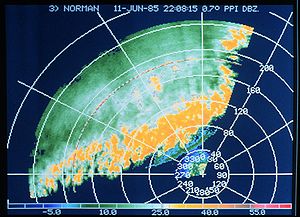 Since data are obtained one angle at a time, the first way of displaying them as been the Plan Position Indicator (PPI) which is only the layout of radar return on a two dimensional image. One has to remember that the data coming from different distances to the radar are at different heights above ground.
This is very important as a high rain rate seen near the radar is relatively close to what reach the ground but what is seen from 160 km (100 miles) away is about 1.5 km above ground and could be far different from the amount reaching the surface. It is thus difficult to compare weather echoes at different distance from the radar.
PPIs are afflicted with ground echoes near the radar as a supplemental problem. These can be misinterpreted as real echoes. So other products and further treatments of data have been developed to supplement its shortcomings.
USAGE: Reflectivity, Doppler and polarimetric data can use PPI.
N.B.: In the case of Doppler data, two points of view are possible: relative to the surface or the storm. When looking at the general motion of the rain to extract wind at different altitudes, it is better to use data relative to the radar. But when looking for rotation or wind shear under a thunderstorm, it is better to use the storm relative images that subtract the general motion of precipitation leaving the user to view the air motion as if he would be sitting on the cloud.
Subscribe to:
Post Comments (Atom)
Post a Comment